
🌏 Introduction: A Railway Map That Looks Like a Bowl of Spaghetti
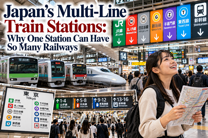
If you have ever looked at a railway map of Tokyo or Osaka for the first time, you may have wondered how anyone manages to understand it. Colored lines cross one another, station names appear in several places, and different railway companies seem to share the same part of the city. One station may connect local trains, express services, underground subway lines, and railways heading toward distant suburbs. The whole network can look like a bowl of spaghetti.
The confusion becomes even greater when you arrive at a major station. You might see signs for JR, Tokyo Metro, a private railway, and several subway lines, all pointing in different directions. Two platforms may serve trains heading toward the same general area, but one route could be faster, another could stop at different stations, and a third might belong to a completely different railway company. Even a station name that looks familiar does not always mean you are standing at the correct entrance.
The reason for this complexity is not simply that Japan has a lot of trains. Multi-line train stations in Japan developed as different railway networks expanded, connected, and grew alongside the cities they serve. Publicly operated railways, private railway companies, subway systems, and other services each contributed to the network over many decades. Their routes reflect different histories and purposes, rather than one master plan created all at once.
There is another important part of the story. Japanese private railways often developed businesses around their stations, including shopping centers, department stores, residential neighborhoods, and entertainment facilities. Stations became more than places to board a train. They developed into major urban centers where people commute, shop, meet friends, and change between different transport systems.
This arrangement can be confusing, but it also makes it possible to travel across large metropolitan areas using an extensive network of connecting lines. Through-service trains even allow some passengers to continue from one company’s railway onto another without changing trains.
Fortunately, the system is not as impossible to understand as the maps might suggest. Japanese and English signs, line colors, station numbers, route-planning apps, and help from station staff can make a complicated journey manageable.
To understand why so many railways meet around a single station name, it helps to look at how the network developed, how different companies operate, and how to use the signs when you are standing inside a busy station.
📖 Table of Contents
- Why Are There So Many Railway Lines in Japan?
- How Private Railways Helped Build Japanese Cities
- Why Different Companies Share the Same Station Area
- Tokyo and Osaka: Two Examples of Complex Railway Networks
- What Is Through Service, and Why Does It Matter?
- Why the Railway Map Looks So Complicated
- How Station Numbers and Line Colors Help
- How to Find the Correct Train and Platform
- What to Do When You Get Lost
- Why Asking for Help Is a Good Idea
- A Simple Way to Understand Japanese Stations
- Conclusion: A Complex Network That Becomes Easier to Use
🏙️ 1. Why Are There So Many Railway Lines in Japan?
Japan’s railway network did not emerge as a single system operated by one company. It developed over a long period through different organizations, public projects, private investment, and changing urban needs. As cities grew and more people began commuting, new lines were built, existing lines were extended, and connections were created between services that had originally operated separately.
Japan’s first railway opened in 1872, connecting Shimbashi in Tokyo with Yokohama. From that beginning, railways spread to other parts of the country, supporting travel, trade, and the growth of cities. Over time, the network came to include national railway services, private railway companies, and urban subway systems. The modern network reflects these different stages of development rather than a single design.
The history of Japan Railways, or JR, is an important part of the picture, but JR does not operate every railway in Japan. The former Japanese National Railways system was reorganized and privatized in 1987, creating the JR group of regional passenger railway companies and related businesses. Many private railways, however, had their own histories long before that change, and urban subway operators developed separate networks to serve the needs of growing cities.
The result is a system with several kinds of railway operating in the same metropolitan area. JR lines may connect different parts of a city with neighboring regions, private railways may link suburban communities with commercial centers, and subways may provide routes through densely built-up urban districts. These services can complement one another, even though they are not all run by the same organization.
This explains why two trains that appear to serve the same city may belong to different companies and use different tracks. They may have been built at different times, for different markets, and to connect different destinations. A railway map brings all those services together for passengers, but the historical boundaries between operators have not simply disappeared.
For visitors, the most useful lesson is that a large station is not necessarily one unified railway system. It may be a meeting point for several networks. Once you understand this, the signs begin to make more sense: the company name and line name are not decorative details, but clues about which route you are following.
🏘️ 2. How Private Railways Helped Build Japanese Cities
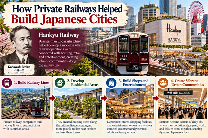
One of the most distinctive features of Japan’s railway history is the role of private railway companies. Many of these companies did more than construct tracks and operate trains. They also invested in the places along their routes, helping to shape the residential and commercial areas that developed around stations.
A particularly influential example is Hankyu Railway in the Osaka region. Its history is associated with businessman Kobayashi Ichizō, who helped develop a business model in which railway operations were connected with housing, retail, and entertainment. The company did not simply wait for passengers to appear. It developed attractions and residential areas that encouraged people to live along the railway and use its trains.
This approach made commercial sense. A railway needs passengers to generate revenue, so creating residential neighborhoods along a line can increase the number of people who travel regularly. Department stores and shopping facilities near major stations can attract customers who arrive by train. Entertainment venues and leisure destinations can generate additional journeys, particularly on weekends and holidays.
Over time, station areas became important centers of urban life. A commuter might take a private railway from a suburban neighborhood, change trains at a major terminal, and then walk through a shopping complex before reaching work. Another person might use the same station to visit a department store, meet friends, or travel to an entertainment district.
The pattern was not identical for every railway company, and it did not mean that every station developed in the same way. Nevertheless, the combination of transport and commercial development became an important feature of many Japanese private railways. Historical studies of Japanese railway development describe how residential land development and department stores became significant parts of the business model. The Japanese government’s publication Highlighting Japan: Urban Development Centered Around Stations explains this relationship through the history of Japanese railways and the development of areas around stations.
This history helps explain why major stations can feel like entire districts rather than simple transport facilities. The railway brings people to the area, while shops, offices, restaurants, and other businesses give them reasons to stay. The station becomes a focal point for movement and commerce.
It also helps explain why multiple railway companies have an interest in reaching major urban centers. If a station is an important destination for commuters and shoppers, connecting a railway to that area can be commercially valuable. As different companies built routes to serve their own passengers, their networks increasingly met around the same major districts.
The result is a railway system shaped by both transportation and urban development. A station can be the place where one journey ends, another begins, and everyday city life continues above and around the tracks.
🚉 3. Why Different Companies Share the Same Station Area
When several railway companies serve the same district, their stations may be located close together, connected by passageways, or incorporated into a larger station complex. From a passenger’s perspective, the area may feel like one enormous station. Operationally, however, the different railway systems can remain separate.
Consider a major city center. One railway company may have built a route there from the north, while another developed a line from the west. A subway operator may later have constructed an underground line through the district. Each company has its own tracks, platforms, operating arrangements, and train services, but passengers need convenient connections between them.
In some places, the stations share a name because they serve the same district or destination. In others, their names are slightly different even though they are geographically close. The naming conventions reflect local history and the choices of the operators involved, rather than a universal rule that every nearby railway station must have exactly the same name.
Osaka provides a clear example. Around the northern city-center district known as Kita, JR Osaka Station sits near several other railway stations serving the Umeda area. Some are operated by different companies and use names such as Osaka-Umeda. The Shinkansen, meanwhile, stops at Shin-Osaka Station rather than the central Osaka Station. These names can sound similar to a first-time visitor, but they refer to different places and services.
The Namba district offers another example. Several railway operators serve the wider area, and their stations may be named Namba or use a variation such as Osaka-Namba. The stations are connected to the same broad urban district, but they are not interchangeable in every journey. A traveler heading to Kansai Airport, for example, needs to check which railway service they intend to use rather than assuming that every station named Namba provides the same trains.
These examples show why the phrase “the same station” can be misleading. Sometimes it refers to a single integrated station complex with several lines. Sometimes it refers to a cluster of separate stations in the same neighborhood. Walking between them may take only a few minutes, or it may require following a long underground passage and several sets of signs.
The practical rule is to identify the exact railway line and destination, not just the station name. If your route says Osaka-Umeda on Hankyu Railway, that is more informative than simply looking for a sign that says Osaka. If you need the Shinkansen, look for Shin-Osaka and the relevant Shinkansen signs rather than assuming that every Osaka-named station serves bullet trains.
Once you recognize that different companies can have stations within the same district, the apparent duplication becomes easier to understand. The names may be similar because the stations serve the same area, while the tracks and train services remain distinct.
🗾 4. Tokyo and Osaka: Two Examples of Complex Railway Networks
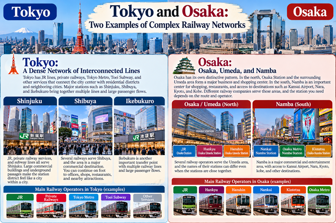
Tokyo and Osaka are often the first places that come to mind when people describe Japanese railway maps as complicated. Both have extensive networks, but their station layouts and patterns of urban development are not identical. Understanding a few well-known examples can help explain why the system varies from place to place.
🗼 Tokyo: A Dense Network of Interconnected Lines
Tokyo has JR lines, private railways, Tokyo Metro, Toei Subway, and other services that connect the city center with residential districts and neighboring cities. Major stations such as Shinjuku, Shibuya, and Ikebukuro serve as important transfer points, bringing together multiple railway lines and large passenger flows.
Shinjuku is particularly striking because the wider station complex includes services operated by different railway companies. JR, private railway services, and subway lines serve the area, while large commercial buildings, underground passages, and surrounding streets make the station district feel like a city within a city. The exact route between two platforms can depend on which company and line you are using.
Shibuya also illustrates how transport and urban development are connected. The area is a major commercial destination, and several railways serve it. Passengers may arrive on JR, a private railway, or a subway line, then continue on foot to offices, shops, restaurants, or nearby attractions.
These stations are not complex because planners deliberately wanted to make navigation difficult. Their current form reflects decades of railway construction, extensions, redevelopment, and connections between services. Some stations have been rebuilt or expanded several times as passenger numbers and urban needs changed.
🏙️ Osaka: Osaka, Umeda, and Namba
Osaka has its own distinctive pattern. In the north, Osaka Station and the surrounding Umeda area form a major business and shopping center. Several railway operators serve this district, and the names of their stations can differ even when the stations are close together.
The city also has an important southern center around Namba, associated with shopping, restaurants, entertainment, and access to other parts of the Kansai region. Different railway companies connect this area with destinations such as Kansai Airport, Nara, Kyoto, Kobe, and other places. The station you need depends on the route and operator.
For example, a passenger traveling to Kansai Airport may use Nankai Railway from its Namba-area station, while another journey may require JR or a different operator. Knowing only that you need “Namba Station” is not always enough. You should check the company, destination, and departure station listed by your route planner.
Osaka’s arrangement demonstrates that a city can have multiple railway centers rather than one single station serving every journey. The same district may contain separate stations that serve different directions and destinations, with walking connections between them.
For travelers, the key difference is not that Tokyo is confusing and Osaka is simple, or the other way around. Both cities have extensive networks, but the important thing is to understand that the name of a neighborhood, the name of a railway station, and the name of a particular operator’s station are not always the same thing.
🔀 5. What Is Through Service, and Why Does It Matter?
Another feature of Japanese railways that can surprise visitors is through service, known in Japanese as chokutsu unten (直通運転). It allows trains from one railway line to continue onto another connected line, often operated by a different company, without requiring passengers to change trains at the boundary.
Imagine boarding a train on a subway line in central Tokyo. Instead of reaching the end of the subway route and making everyone leave the train, the service may continue onto a private railway that heads toward the suburbs. The train may change railway lines, but passengers can remain in their seats and continue their journey.
This arrangement can make travel much more convenient. It reduces the need for transfers and connects destinations that might otherwise require passengers to cross a station, pass through gates, or wait for a separate train. For commuters, through service can create a continuous route between a residential area and a central business district.
However, the arrangement also makes the railway map more difficult to read. A train that begins on one company’s line may continue onto another company’s tracks, and the final destination displayed on the train may be far beyond the part of the route you recognize. The line name on a map does not always tell the whole story of where a train will eventually go.
Through service also requires compatible infrastructure and operating arrangements. Railway companies must coordinate matters such as track connections, train equipment, signaling systems, and operating schedules. Not every line can connect directly with every other line, and through service is available only on specific routes.
This is why it is important to pay attention to the train’s destination and service type, not just the color of the line on a map. A local train and an express train may use the same route but stop at different stations. A train that continues beyond the subway section may take you much farther than you expect if you board without checking its destination.
For visitors, the good news is that you do not need to understand the technical details of through service to use it. A route-planning app or station sign can tell you which train to take and where to get off. The concept simply explains why some journeys cross company boundaries without requiring a transfer, and why a single train may appear on more than one railway map.
Through service is a good example of the trade-off at the heart of Japan’s railway system: integrating separate networks can make journeys more convenient, but it can also make the overall system harder to visualize.
🗺️ 6. Why the Railway Map Looks So Complicated
A railway map is designed to show how routes connect, not necessarily to reproduce the geography of the city exactly. Lines are often drawn at simplified angles, station spacing may be adjusted for readability, and many routes cross at different points. In a large metropolitan area, the result can look like a dense web of colored lines.
There are several reasons for this complexity. First, different railway companies developed routes at different times. Second, urban subway lines were added to serve areas that existing railways did not cover conveniently. Third, extensions and through-service connections created links between networks that were once separate. Finally, the map needs to show enough information for passengers to choose routes, identify stations, and make transfers.
The map is therefore a tool, not a complete picture of how a station works. A diagram may show two lines meeting at a station, but it may not communicate how far apart the platforms are, whether you need to exit one paid area and enter another, or how long the transfer takes. A station that looks simple on paper can involve a substantial walk underground.
The opposite can also be true. A map may look intimidating because it contains dozens of lines, but a particular journey may require only three steps: find the correct starting station, follow one line to a transfer point, and board the next train to your destination. You do not need to understand the entire network to complete one journey.
It helps to think of the railway map as a menu of possibilities. You use the part that matters to your trip, rather than trying to memorize every route. If you are traveling from Shibuya to Ueno, for example, you need to identify a suitable route between those two places, not learn every line operating in Tokyo.
Route-planning apps are especially useful because they filter the network according to your origin and destination. They can show the recommended line, transfer station, platform information where available, estimated travel time, and sometimes the station’s line code. Even then, check the signs at the station because platform assignments and service arrangements can change.
The map becomes easier when you stop treating every colored line as a separate puzzle to solve. Instead, start with your destination and follow the recommended route. Then use the station’s signs to confirm that you are following the correct company and line.
🔢 7. How Station Numbers and Line Colors Help
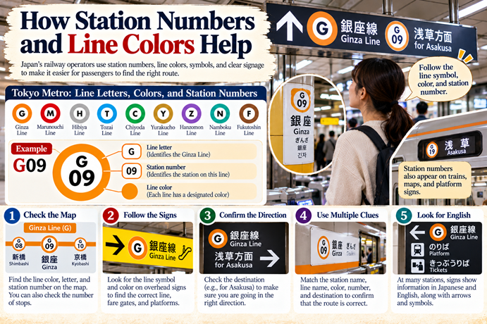
Japan’s railway operators use several kinds of visual information to make stations easier to navigate. Japanese and English station names, line colors, symbols, arrows, and station numbers can help passengers identify the correct route even if they cannot read every Japanese character.
Tokyo Metro provides a particularly clear example of station numbering. Each Tokyo Metro line has a letter, and each station on that line has a number. The letter identifies the line, while the number identifies the station within that line. The line’s designated color provides another visual cue.
For example, a station code such as G09 indicates a station on the Ginza Line, with the number identifying its position in that line’s numbering system. The code is useful because a passenger can compare the station number on a map with the number displayed on signs. It can also help the passenger count the number of stops between stations.
The code is not a universal identifier for every railway station in Japan. Other railway operators use their own numbering systems, and not all services use the same format. Therefore, station numbers are best treated as a navigation aid within the relevant system, rather than as one nationwide code covering every train.
Line colors serve a similar purpose. If you are following a subway map, the color and line symbol help you identify which route to follow. When you reach a station, overhead signs can direct you toward the appropriate line, fare gates, and platforms. Tokyo Metro’s official subway map and station-number guide explains how these letters, numbers, and colors work together.
English signage is another important tool. At many major stations, signs display Japanese and Roman-letter station names, line names, destinations, and transfer information. Some stations also provide additional multilingual information. The level of detail varies by operator and location, so travelers should still check their route carefully.
A useful strategy is to match more than one clue. If your route says to take the Ginza Line toward Asakusa, look for the Ginza Line symbol and color, then confirm the direction and destination. If the station number is available, use it to double-check that you are at the right stop. Relying on a single clue can be risky when stations have several lines and similarly named destinations.
The purpose of these signs is to make a complicated network more manageable, not to remove every possible source of confusion. They work best when passengers use them together: station name, line name, color, number, and destination all help confirm that the route is correct.
🚶 8. How to Find the Correct Train and Platform
When you enter a major station, the first question is not simply “Where is the train?” It is “Which railway and which line do I need?” That distinction is important because a large station may contain several sets of platforms operated by different companies.
Start with the route shown by your map or journey-planning app. Check the exact station name, railway operator, and line. If the route says JR, do not automatically follow a sign for a nearby subway line just because it appears to go in the same direction. The services may have different stops, fares, or transfer arrangements.
Next, follow the overhead signs toward the relevant line. Large stations often have signs at entrances, concourses, passageways, and stairways. The information may include the line’s name, color, symbol, destination, and platform number. If the signs indicate a transfer, check whether you need to remain inside the station’s paid area or follow a route to another company’s gates.
Once you reach the platform, confirm the train’s destination and service type. Some lines have local, rapid, express, or limited-express trains, and these services may stop at different stations. A train can be on the correct line but still skip your destination if it is an express service. The route planner should indicate the type of train to board.
It is also useful to check the direction of travel. In a circular or branching network, knowing the line name alone may not be enough. The platform signs may display the terminal station or the main direction of travel. Compare that information with the route shown in your app.
Do not assume that the shortest-looking route on a map is necessarily the easiest one. A transfer may involve a long walk or a complicated change between operators. If you are traveling with luggage, children, or someone who needs step-free access, a route with fewer transfers may be more convenient even if it takes slightly longer.
Finally, allow enough time for transfers at major stations. A journey planner may estimate the transfer time, but the actual walk can feel longer if you are unfamiliar with the station. If you arrive at the platform and discover that you have taken the wrong passage, stop and check the signs rather than rushing in the wrong direction.
A reliable routine is to confirm the operator, line, direction, and destination before boarding. It takes only a few moments and can prevent a great deal of confusion.
🙋 9. What to Do When You Get Lost
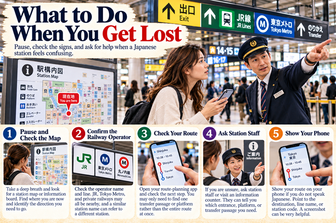
Getting lost in a large Japanese station is not unusual, especially when you are visiting for the first time. You might follow the correct line color but reach the wrong company’s entrance, emerge on the street when you intended to transfer underground, or discover that the station name on your map refers to a nearby but separate station.
The first thing to do is pause. Continuing to walk quickly in the hope that the signs will eventually make sense can take you farther from your destination. Look for the nearest station map, information board, or sign showing the line you need. Compare it with the route on your phone and identify where you are now.
If you have mobile data, open your route-planning app and check the next step rather than trying to interpret the entire network. You may only need to find one transfer passage or one platform. A large station can seem overwhelming when you look at every possible route at once, but a single journey usually has a limited number of steps.
If you are unsure whether you are inside the correct station, check the operator name. For example, JR, Tokyo Metro, and a private railway may all serve the same district. The company logo and line name can help you distinguish the correct entrance. A nearby station with a similar name may be a different station operated by another company.
If the map and signs do not resolve the problem, ask for help. Station staff, where available, are often the most useful people to approach because they can explain which entrance, platform, or transfer passage you need. Information counters may also be available at larger stations, although not every station has one.
You can show the route on your phone if you do not speak Japanese. Pointing to the destination, line name, or station code may be enough to communicate what you need. A screenshot can be especially useful if the station is noisy or you are having trouble explaining the route verbally.
If you realize you have boarded the wrong train, do not panic. Check the next station and use the route planner to determine how to return to the correct route. In many cases, you can get off at a suitable station and change trains, although the best option depends on the line and service. Check the signs before crossing any ticket gates or making a transfer that could affect your fare.
The important thing is to treat confusion as a normal problem to solve, not as a personal failure. Even people who live in Tokyo or Osaka may need to check unfamiliar routes or use station maps when traveling somewhere new.
🤝 10. Why Asking for Help Is a Good Idea
Some visitors hesitate to ask for directions in Japan. They may worry that their Japanese is too limited, that the other person will not understand English, or that interrupting someone is impolite. These concerns are understandable, especially when a station is crowded and everyone seems to be moving quickly.
However, asking a clear and polite question can be much easier than trying to solve a complicated transfer alone. If you cannot find the right platform, you do not have to pretend that you understand the signs. A station employee or another passenger may be able to point you toward the correct passage or explain which line you need.
When possible, begin with station staff or an information counter. They are more likely to know the station layout and can often give precise directions. If you cannot find staff, you can politely ask someone nearby. Choose a moment when the person does not appear to be rushing to board a train, and keep your question short.
Here are three useful English phrases:
“Excuse me, how do I get to the JR line?” This is useful when you are in a station complex but cannot find the entrance or passage for JR.
“Is this the right platform for Shibuya?” This helps confirm whether you are waiting in the right place. If possible, show the station name or destination on your phone.
“Could you show me on the map?” This is helpful when spoken directions are difficult to follow. A person may be able to point to a passage or show you which line to take.
You can also use a simple Japanese phrase:
「すみません、〇〇駅へはどう行けばいいですか?」 — Sumimasen, 〇〇-eki e wa dō ikeba ii desu ka? This means, “Excuse me, how do I get to [station name]?”
You do not need to pronounce every word perfectly. You can show the destination on your phone, point to a line symbol, or use the station name in Roman letters. Combining a short question with a visual reference often makes communication easier.
It would be inaccurate to promise that every person will always be able to help. Some passengers may be in a hurry, may not know the station well, or may not understand your question. If the first person cannot help, try a staff member or another source of information. There is no need to take a brief refusal personally.
The important message is that asking for directions is a reasonable response when you are lost. Japan’s railway system is extensive, and even a well-designed sign system cannot answer every question in every situation. A little human assistance can turn a confusing station into a manageable part of your journey.
🧭 11. A Simple Way to Understand Japanese Stations
You do not need to memorize the entire railway network to travel successfully in Japan. A more effective approach is to break each journey into a few small decisions: identify your destination, find the correct railway line, follow the signs to the platform, and confirm the train’s direction before boarding.
Think of the railway map as a network of connections rather than a puzzle you must solve all at once. You only need to understand the section relevant to your trip. If your journey involves one transfer, focus on the station where that transfer occurs and the line you need to take next.
It also helps to remember that the station name may not tell you everything. In districts such as Umeda or Namba, several companies serve the same broad area. Check the exact name and operator shown by your route planner. If you need the Shinkansen, make sure your route takes you to the correct Shinkansen station rather than a nearby local station with a similar name.
Use the station’s visual information systematically. Match the line name, color, symbol, and station number where available. Confirm the destination on the train display or platform sign. If any detail does not match your route, stop and check before boarding.
For a first-time visitor, planning the route before entering a large station can reduce stress. Save the destination name, note the line and transfer station, and keep the route available on your phone. You do not need to plan every movement in advance, but knowing the next step can make the station easier to navigate.
If you live in Japan, these habits remain useful when visiting an unfamiliar city. A person who understands Tokyo’s subway may still need to learn the layout of Osaka’s railway stations, and someone familiar with Osaka may find a different city’s network unfamiliar. Each region has its own operators, signage conventions, and station arrangements.
The more you use the network, the more familiar its patterns become. You begin to recognize the difference between JR and subway signs, understand how station numbers work on a particular line, and anticipate where transfers may be located. What first looks like a tangled mass of routes gradually becomes a set of manageable connections.
Most importantly, give yourself time. Large stations are not always intuitive, and even experienced travelers sometimes take the wrong passage. Checking the signs, using a route planner, and asking for help when necessary are all normal parts of traveling by train.
🌟 12. Conclusion: A Complex Network That Becomes Easier to Use
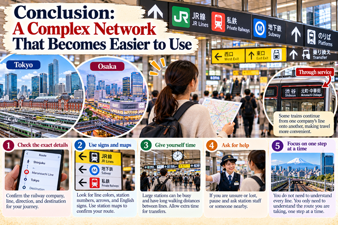
Japan’s multi-line train stations can look like a maze because they bring together railway networks that developed over many decades. JR services, private railways, subway systems, and through-service connections all play different roles in moving people across cities and between urban centers and their surrounding regions.
Private railway companies helped shape the cities around their routes by developing residential areas, shops, department stores, and entertainment facilities. As urban populations and travel needs grew, different railways connected at major stations and commercial districts. The resulting networks are not always simple to understand, but they provide many ways to move around large metropolitan areas.
Through service adds another layer of convenience by allowing some trains to continue from one company’s line onto another. At the same time, station numbers, line colors, Japanese and English signs, and route-planning apps help passengers identify the right route. These systems do not eliminate every possible confusion, but they make the network easier to use.
If you are visiting Japan, remember to check the exact railway company, line, direction, and destination rather than relying only on the station name. Give yourself time to find transfers, especially at large stations, and use the signs and maps to confirm each step. If you become lost, pause and ask station staff or someone nearby for help.
You do not have to understand every line in Tokyo or Osaka to travel confidently. You only need to understand the route you are taking, one step at a time. And if the station still feels like a bowl of spaghetti, that is all right. Check the signs, look at your map, and ask for help when you need it.
🔗 Explore More of Life in Japan
Understanding Japan’s railway network is one part of learning how everyday life works in the country. Explore more practical explanations of Japanese routines, public services, and daily experiences in the Life in Japan section of Real Japan Navigator.
👉 Plastic Shopping Bags in Japan: Should You Buy One or Bring Your Own?
👉 How Much Luggage Should You Bring to Japan? Why Less Is Often Better
👉 Which Side Should You Stand on an Escalator in Japan? Tokyo, Osaka, and the World
👉 Staying at a Japanese Ryokan: What to Know About Dinner, Yukata, Tatami, and Onsen Etiquette